

Monarch's Way - An Introduction to a 625 mile footpath
Monarch's Way T shirts and Hoodies
Monarch's Way Guide Books & Badges
Maps & Postcards of the Monarch's Way
Cotswolds Guide Books & Maps of the Monarch's Way
Warwickshire - The Monarch's Way
Temporary Amendments to The Monarch's Way
Places to Visit along The Monarch's Way
Walks Around The Monarch's Way
Bird News along The Monarch's Way
Amanda's Charity Walk Ham Hill to West Bay
Oak Apple Day 29th May 2012 Guildhall Worcester
Changes to the Route of the Monarch's Way
Minder's at work along the Monarch's Way
Trevor's Boot Relay Pictures part 2
Trevor's Boot Relay Pictures part 3
Trevor's Boot Relay Pictures part 4
Trevor's Boot Relay Pictures part 4A
Trevor's Boot Relay part 5 Book 2
The Monarch's way Relay part 8 (updated)
The Monarch's Way Relay part 9
The Celebration into Charmouth-Trevor's Boot Relay part 10
The Monarch's Way Relay part 11 Book 3
The Monarch's Way Relay Part 12
The Monarch's Way Relay part 13
The Monarch's Way Relay part 14
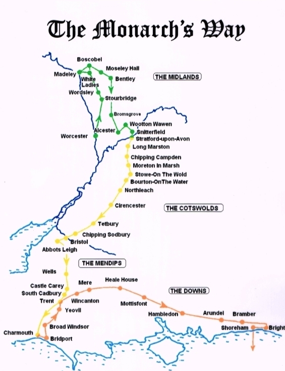
The Walk This long distance walk 625 miles using footpaths and bridleways closely follows the route taken by Charles and enables you to visit many historic sites and buildings, maybe only previously known to you through the history books. It also takes you through two World Heritage Sites, one National Park and six Areas of Outstanding Natural Beauty plus some of the finest scenery in western and southern England.
Email : Contact@monarchsWay.50megs.com To get free automatic Membership of the Association.
This entitles you to the twice yearly News Letters (March & September) & Free Completion certificates (for up to 2 people for each Guide Book purchased)
|
 |
|
The Monarch’s Way connecting paths Vital Statistics! Worcestershire (incl. Worcester City)..................59 Shropshire.........................................................32 West Midlands (the former County of)..................29 Staffordshire......................................................37 Warwickshire......................................................31 Gloucestershire..................................................90 Avon (the former County of)(incl.Bristol City).......46 Somerset.......................................................... 94 Dorset............................................................... 60 Wiltshire........................................................... 43 Hampshire.........................................................60 West Sussex.......................................................45 East Sussex (incl. Brighton/Shoreham)................14 Ordnance Survey Maps Covering the Whole of The Monarch's Way OS Explorer (1:25,000) Series - OL45; 116; 117; 119; 120; 121; 122; 129; 130; 131; 132; 141; 142; 143; 155; 167; 168; 204; 205; 218; 219; 220; 221; 242. OS Landranger (1:50,000) Series - 127; 138; 139; 150; 151; 163; 172; 173; 182; 183; 184; 185; 193; 194; 196; 197; 198. As ever we would strongly recommend anyone seriously contemplating walking either the whole, or substantial parts, of the Way to use the OS Explorer series |
|