Monarch's Way - An Introduction to a 625 mile footpath
Monarch's Way T shirts and Hoodies
Monarch's Way Guide Books & Badges
Maps & Postcards of the Monarch's Way
Cotswolds Guide Books & Maps of the Monarch's Way
Warwickshire - The Monarch's Way
Temporary Amendments to The Monarch's Way
Places to Visit along The Monarch's Way
Walks Around The Monarch's Way
Bird News along The Monarch's Way
Amanda's Charity Walk Ham Hill to West Bay
Oak Apple Day 29th May 2012 Guildhall Worcester
Changes to the Route of the Monarch's Way
Minder's at work along the Monarch's Way
Trevor's Boot Relay Pictures part 2
Trevor's Boot Relay Pictures part 3
Trevor's Boot Relay Pictures part 4
Trevor's Boot Relay Pictures part 4A
Trevor's Boot Relay part 5 Book 2
The Monarch's way Relay part 8 (updated)
The Monarch's Way Relay part 9
The Celebration into Charmouth-Trevor's Boot Relay part 10
The Monarch's Way Relay part 11 Book 3
The Monarch's Way Relay Part 12
The Monarch's Way Relay part 13
The Monarch's Way Relay part 14
A few selected items from the many that appear in The Monarch's Way Bulletin.
Footpath News
As one might expect, after a period of some 14 years and over a distance of 625 miles, a few changes to the route will inevitably occur. As a service to Monarch's Wayfarers the Association are in the process of putting all route changes onto the web site. See the routes changes pages for Books 1,2 and 3.
We are aware that this very short section of culvert near Haselbury Mill was in fact a permissive route and that the occupier, for reasons of which we are unaware and even more surprised, has withdrawn permission. This means then that walkers are now again faced with having to cross the busy A30 road instead of passing under it. Whilst both SSDC and SCC are attempting to resolve this problem, as a matter of some urgency, walkers should be guided accordingly and, perhaps realistically, expect any solution to take some time to reach. 'One step forward and one step back!'
The Monarch's Way Accomodation Guide Visitors are advised that maintenance of the MW Accomodation Guide now rests again with the Association. This is in three parts to coincide with each of the three books on The Monarch's Way. To obtain your copy(s) please state which part you require and email Contact@monarchsway.50megs.com
The following are just a selection of comments made about The Monarch's Way.
'I just gave my recovering heel a good test over the Golden Cap section of The Monarch's Way. What wonderful views!' (Irene Hazelwood - Worcestershire) 'We had a great time and frequently marvelled at the amazing achievement in creating this route and the many footpaths that have been saved/improved.' (Lizzy and John Hornsey - Sussex - as far as we are aware, the first End to Enders to have completed the MW in 38 consecutive days). 'We have just spent a superb bank holiday weekend walking from Tresham down to Keynsham. The sun shone (for most of the time!) and the countryside was at its glorious best - trees, wild flowers, birds, bluebell woods and wild garlic. Once again the Monarch's Way did us proud.' (Brenda Luck - Staffordshire). '....the main reason for writing is to say a huge 'thank you' for the work and idea of the route. We cannot begin to imagine the amount of work that must have been involved, but it was worth while. The route led us through some of the most spectacular scenery in England, and with so little contact with roads and villages or towns. Absolutely fabulous.' (Sarah & Mike Wallace - Sussex). .....'A wonderful walk that records history, is well documented, created by one man and gives pleasure to the many who walk through this green and pleasant land of England.' (Anne Haynes - West Midlands) '....I must start by expressing our appreciation of the excellent way marking on the parts of the Monarch's Way that we recently walked.....we had no problems with route finding and were very impressed with the small 'stick-on' waymarks.' (Chris Edgeley - Isle of Wight) '....We have been inspired to tackle Book I, very enjoyable, great work.' (Paul, Wendy & Charlotte Kneller - West Midlands) '.....That was all amazingly quick and helpful - thank you so much for all your efforts, far beyond the call of duty!' (Tony Wilson - Cambridge) 'The Monarch's Way is Britain's second longest signed walking trail and passes through the District. This high profile and well-networked path provides a strong backbone for a network of green corridors to link key open space sites with settlements'. (Salisbury District Council - Open Space Study 2006 para. 11.7 page 122) '.......We thoroughly enjoyed the walk and the historical associations added greatly to our enjoyment. The waymarking was excellent and your book invaluable for route finding.' (Ruth & Terry Griffiths - South Yorkshire) 'It is a wonderful walk and deserves to be better known', (John Harris - Berkshire) ' ...A wonderful concept' (Tony Wilson - Cambridge) 'Thanks for the accomodation list. I would be grateful if you would convey our sincere thanks to the 'minders' of the section through the woods north of North Wooton. The way marking was outstanding and most welcome on a wet, grey Sunday last weekend. We walked from Wells to Castle Cary on Sunday and Castle Cary to Sandford Orcas on Monday. Monday was brilliant and the views from South Cadbury and Corton Ridge were outstanding, (Tim Hipkiss - Worcestershire)
'Just to say that I had a very good stab at the route. I started off walking with a backpack, tent and food but after about 100 miles decided that I wasn't strong enough for another 500 so I returned for my bike and continued where I broke off using Byways and some of the Bridleways. Your books were an excellent guide and I thoroughly enjoyed the trip making my summer truly memorable. (Tony Golding - West Sussex). 'Thank you again for devising this fascinating walk.' (Chris Billinghurst - North Somerset) 'By the way, the concept of the walk and ingenuity of the route are wonderful; also the directions and comments in the text are spot on, so thank you very much for designing a great trail.' (Linda & Steve Tovey - Surrey) ......'your walk ticked all the boxes for me.' (Keith Percival - Hampshire) .......'On behalf of the group, may I thank you for producing such an excellent guide. We can certainly blame some of the local authorities for poor paths but your clear instructions never let us down. We walked through some beautiful countryside & visited some fascinating places - this year one participant even purchased new walking boots as we passed Peglars in Arundel. All in all a lovely project that will remain in our memories for many years to come.' (Christopher Cheverst - Leader of the 2001/10 Monarchs' Way Walking Group).
'May I say how much I enjoyed the walks and thank you for your excellent books. I would also like to say that I used public transport throughout, which shows it can be done!'. (David Wearing - Berkshire).
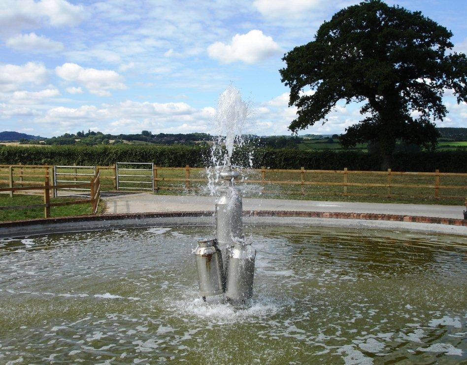
Milk Churn Fountain - Somerset. This is no longer visible from the Monarch's Way due to a minor route alteration |
|