

Monarch's Way - An Introduction to a 625 mile footpath
Monarch's Way T shirts and Hoodies
Monarch's Way Guide Books & Badges
Maps & Postcards of the Monarch's Way
Cotswolds Guide Books & Maps of the Monarch's Way
Warwickshire - The Monarch's Way
Temporary Amendments to The Monarch's Way
Places to Visit along The Monarch's Way
Walks Around The Monarch's Way
Bird News along The Monarch's Way
Amanda's Charity Walk Ham Hill to West Bay
Oak Apple Day 29th May 2012 Guildhall Worcester
Changes to the Route of the Monarch's Way
Minder's at work along the Monarch's Way
Trevor's Boot Relay Pictures part 2
Trevor's Boot Relay Pictures part 3
Trevor's Boot Relay Pictures part 4
Trevor's Boot Relay Pictures part 4A
Trevor's Boot Relay part 5 Book 2
The Monarch's way Relay part 8 (updated)
The Monarch's Way Relay part 9
The Celebration into Charmouth-Trevor's Boot Relay part 10
The Monarch's Way Relay part 11 Book 3
The Monarch's Way Relay Part 12
The Monarch's Way Relay part 13
The Monarch's Way Relay part 14
|
However be aware that the inside of the tunnel is still fairly wet and has some rather deep potholes, particularly at the Old Hill end. Netherton Tunnel Opened in August 1858, the unlit Netherton tunnel stretches 1.7miles (3027 yards) underground and is a key link between the northern and southern Birmingham Canal Navigations. The tunnel was the last to be built in Britain during the canal age. It was built wide enough to allow boats to pass in both directions and constructed to relieve the bottleneck of the adjacent Dudley tunnel, which had waiting times of eight hours or more, and sometimes several days. Built using pick and shovel, the construction of this impressive feat of Victorian engineering was not without its risk and during construction nine men were killed and eighteen seriously injured. Due to the nature of its design and as a result of the local ground conditions, cracks have appeared in the Victorian brickwork with many ‘bunching up’ and breaking off. This has caused serious concern for our engineers which have now started the repair works that will safeguard the tunnel’s future. The project will cost £1.5million and involves carrying out repairs to a 50 metre centre section of tunnel almost a mile into the tunnel. Engineers are drilling holes within the tunnel wall, filling these holes with steel tubes which are then filled with concrete. Once set this section of tunnel will also be reinforced with a new arch to create a stable centre section. George Ballinger, head of engineering at the Canal & River Trust, said: “We have been keeping a close eye on Netherton Tunnel for some time and have carried out various repairs over the years, the last being in the early 1980s. The centre section of tunnel that will be repaired over the weeks ahead has really got us concerned and, ultimately, if we did nothing the tunnel could collapse. “The works being carried out will help prevent any further movement of the centre section, giving it strength and support for generations to come.” Monarch's Way / South West Coast Path Heavy Rain has caused increased critical damage along the section which coincides with the South West Coast Path. Please do not venture on the paths by Charmouth or Golden Cap, these areas have high landslip warnings. Updated 13th February 2014 From time to time we learn of changes to the route along the Monarch's Way. This can be due to planning applications or other required diversions due to climate change, global warming or whatever; what is sure is that these sudden events can cause disruption to walks and the planning of them. This then is an attempt to assist members and Users in their planning. |
||
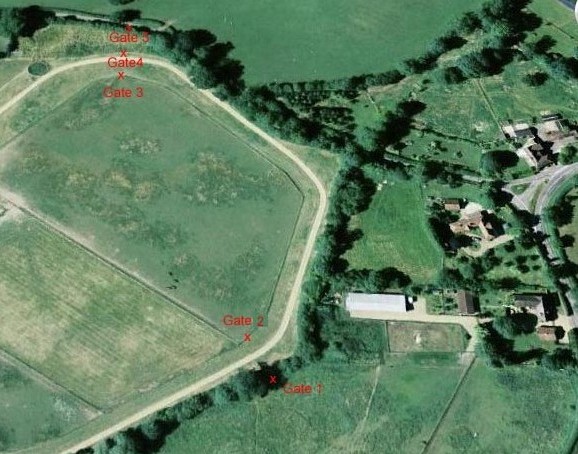 |
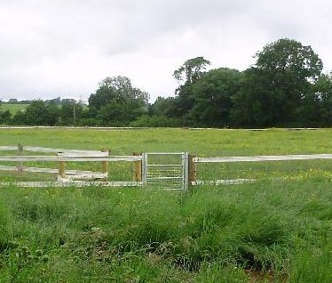
Book I Section 16 Headless Cross to Alcester. We have had a warning on the web site concerning access across this horse training and exercise track around the area before Astwood Court for some time.
|
|
 |
|
|
|
|
||